
New Miles: 13
Actual Miles Hiked: 13
Overall Progress: 100.9 out of 900 miles
9-3-14
Today I sought out to conquer the Bull Head Trail, but all I got was the horns. This trail kinda sucked! Okay, it really sucked! In all fairness, it wasn’t just the trail that sucked–today was just one of those 0ff-days that everybody has while hiking. It was the kind of day when your mind and your feet don’t quite sync up and you find yourself slipping and stumbling all over the trail. I found myself thinking feet! what is wrong with you? Why aren’t you working? Nonetheless, we, myself and my clumsy feet, made it the entirety of journey…. it just took a little longer than I had hoped.
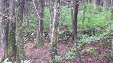
Bull Head Trail can be accessed off the Roaring Fork motor trail near Gatlinburg, TN. I parked at the Rainbow Falls trail head with the intention of completing the 13 mile loop and getting all “new miles” for today (there aren’t many natural loops within the park, so much of the 900 Mile Challenge is spent backtracking over previous trails). I decided it would be best to hike up Bull Head trail as most folks would be hiking the other way to see the falls. It was a good decision; I only encountered 2 hikers on the way up to Le Conte. The trail starts on the side of the mountain–there’s no switchbacks, just straight up the side of the mountain. The trail was abnormally wide, so I figured it must have been an old logging road or wagon trail. Off to the side, an old stone fence stands guard–keeping in the ghosts of old cattle. It reminds me of the old Robert Frost poem, The Mending Wall.
Onward and upward it went; did I mention straight up? This trail gained 4,000 ft of elevation over 6 miles; it was a constant uphill battle with no reprieves! To top it all off, the weather was hot and humid. I was drenched in sweat just 15 minutes into the hike. Eventually the trail started carving switchbacks into the edge of the mountain, tracing it’s circumference. About 4 miles of the trail follow under these huge rock bluffs, boasting boulders the size of bulldozers and houses.


Views of Gatlinburg peaked through the trees on occasion. At one break in the foliage, I realized that I was hiking above the clouds–how is that for perspective?

Eventually the trail wraps around the side of the mountain, leading to inward cove that reveals the true height of Mt. Le Conte; seeing the summit of the mountain looming before me was quite intimidating–my legs groaned in pain! It felt like I was getting nowhere. It didn’t help that this trail didn’t offer much on the side of natural features, like overlooks and caves. There were just a few gaps in between some trees offering a glimpse of the scenery. The trail leveled off for a whole 5 minutes…flat land! And then, just as quickly as the trail crossed over this level spine on the mountain, it started marching upward again…through a dark tunnel of Rhododendron trees.

The farther up the mountain I climbed, the more apparent it became that this trail was the original route, by which, guests of the historic Le Conte Lodge must has first traveled. At many places, neatly placed stones lined the trail, looking as if they were placed there by the hands of a skilled mason. The trail maintained it width and wagon ruts could be seen from time-to-time.


By this time, I was getting really tired and really hungry! The heat was oppressive and was I consuming water like crazy. I kept waiting for the trees to change, but they didn’t. When I hike, I pay careful attention to the trees and plants that line the trail. Seeing Balsams and Christmas trees lets me know that I am making upward progress–I’m getting really close to the top. As the Christmas tress get shorter, I know I am about to cross into the Alpine Zone. These are always helpful indicators as to my progress. Still, no Christmas trees–just big rhododendrons and Mountain Laurels. They mocked me! It felt like I was hiking at a snail’s pace. Then I saw this little guy; what perfect timing!

Finally, the trail made its way up in elevation. I could smell the sweet scent of Christmas Trees in the air. Not much longer after that, I had reached the top of Mt. Le Conte and the junction of the Rainbow Falls trail. By this time, the weather was beginning to change and a thick shroud of fog blanketed the trail. I hiked downward for several miles and started to see more tourists…big surprise. They were all hiking up to Le Conte Lodge and all were ill prepared. It never ceases to amaze me what people will wear on a rainy, muggy day in the woods. Blue jeans and cotton shirts were the mainstay of today’s trail fashion. I bet they didn’t even pack rain jackets with them! Nonetheless, I just kept hiking downward through the drizzling rain.
The trail finally made it to the famous Rainbow Falls. It was a beautiful site, but there was no rainbow today–no sunshine to refract off the waterfall. I sat down and took in the scenery. It was a welcome reprieve for my sore feet and burning legs. My body just wasn’t enjoying this hike! 
One more stop on-the-way down…Lesser Falls. I lingered for a while here, as there were no tourists. It was quite wonderful and I basked in the moment. 
All-in-all, I was disappointed with today’s hike. I guess I was so impressed by all the features and scenic overlooks that Alum Trail had to offer that this trail just didn’t compare. At least there were far less tourists! However, straight up the side of the mountain with no switchbacks or changes in grade is not my idea of a fun hike. Regardless, I must keep hiking…I only have 800 more miles left! Stay tuned!


